Lao People’s Democratic Republic (Lao PDR) – or simply Laos – is a country in Southeast Asia. Laos spans an area of 236,800 square kilometers and borders 5 countries, including China to the north, Vietnam to the northeast and east, Cambodia to the south, Thailand to the west, and Myanmar to the northwest.
Laos has a population of over 7 million people as of 2024. The official system now divides Laos’s population into four different ethnolinguistic groups: Lao-Tai (main group), Mon-Khmer, Hmong-Mien, and Chinese-Tibetan. Despite the numerous languages spoken, Lao is the official language of the country, used in government, education, and such.

Laos’s map with neighboring countries (Source: Mappr)
On the government side, Laos is a communist country led by the Lao People’s Revolutionary Party (LPRP). Top government officials are the president and the prime minister. The former is the head of state, while the latter is the head of government.
The economy of Laos relies heavily on agriculture, with rice as the main crop. Other crops include corn, sweet potatoes, sugarcane, and some vegetables and fruit. Mining is another important sector, with tin, gypsum, and gold being the most important resources. In addition, granite, limestones, copper, and precious stones are also being mined – some by foreign companies.

Farmers on a rice paddy in Laos (Source: Sowing Diversity = Harvesting Security (SD=HS) Program)
Around 70% of Laos’s area is covered by mountains and plateaus. They dominate the north and southeast parts of the country.
Northern Laos is full of towering mountains having an average elevation of 1,500 meters above sea level. Phou Bia is the highest peak among them, piercing the sky at 2,800 meters.
Meanwhile, the Annamese Mountains (also known as “Phou Luang” in Lao), stretch from the Phouane Plateau all the way to the Cambodian border. This mountainous region consists of three plateaus: Phouane in Xieng Khouang, Nakai in Khammouane, and Bolaven in southern Laos.

Mount Phou Bia (Source: @Chaoborus via Wikimedia Commons)
On the other hand, the Mekong River flowing through almost 1,900 kilometers of the country from the north to the south is the main geographical feature of Laos. The rest 30% of Laos’s area is the plain region consisting of large and small plains gathering along this very river and its tributary.
The largest of these is the Vientiane Plain (Nam Ngum River). Also significant are the Savannakhet Plain (Se Bang Fai and Se Bang Hieng Rivers), and the Champassak Plain stretching between the Thai and Cambodian borders. Blessed with fertile soil, these plains are the “granaries” of the country.

A section of the Mekong River in Luang Prabang (Source: One For The Road Photography by Brendan Caffrey)
Laos experiences a tropical climate shaped by the monsoons. Thus, the year is divided into two distinct seasons: the rainy/monsoon season (May to mid-October), and the dry season (mid-October to April). Rainfall varies considerably across the country, with annual averages ranging from 1,300 to 3,000 millimeters, and can be heavy especially during the later months of the rainy season (late July to September) in the southern regions.
Within each season there are also variations in temperature, with the last months of the dry season (March and April) and the early rainy season (May and June) typically being the hottest – around 35°C in the Mekong River valley. That said, temperatures tend to be cooler in the mountainous north and east, averaging around 20°C.

A saola – regarded as the “Asian Unicorn” – in the Annamese Mountains’ rainforest (Source: Rainforest Trust)
In detail, Laos can be divided into 3 climatic zones as below:
Having a “Humid subtropical, dry winter” as classified by the Köppen climate classification, Luang Prabang has distinct hot and cool seasons, similar to Hanoi.
The hottest month is June with an average high of 31.1°C, while December is the coldest with an average low of 14°C. Looking at these figures, you can say that Luang Prabang is generally quite warm. The humidity is also high throughout 9 months of the year – from February to December – having July as the most muggy month.

The streets in Luang Prabang (Source: The Luang Say Lodge & Cruises)
As for the rain, it rains most from March to November, with August seeing the most rainfall at 162.56 millimeters approximately. The remaining rainless period, however, witnesses just 5.08 – 12.7 millimeters.
If you want to visit Luang Prabang, the best time for general outdoor activities is from early November to mid-March. For hot weather activities, early March to late April is ideal.

A corner of the Royal Palace Museum in Luang Prabang (Source: Sofitel Luang Prabang)
Vientiane is slightly hotter and has more rainfall than Luang Prabang. It has a similar climate pattern to the Central Highlands in Vietnam: the tropical savanna – with distinguishable rainy and dry seasons.
The hottest months here are March to May. April is the hottest overall – having an average temperature of 24,4°C to 34,4°C. December is the coolest month, having an average temperature of 17.2°C to 28.3°C. The humidity is very close to Luang Prabang, with July being the most muggy month as well.

That Luang in Vientiane (Source: Nations Online Project)
Rain in Vientiane occurs most from February to November, with the greatest amount of rain in August being around 213.36 millimeters. However, during the dry season, there is almost no rain at all during December and January – contrary to a minimum of 5.08 millimeters of rain in Luang Prabang.
In general, it’s best to visit Vientiane from late November to mid-February. Or if you prefer hot weather, late January to late March and late October to late November could be a good choice.
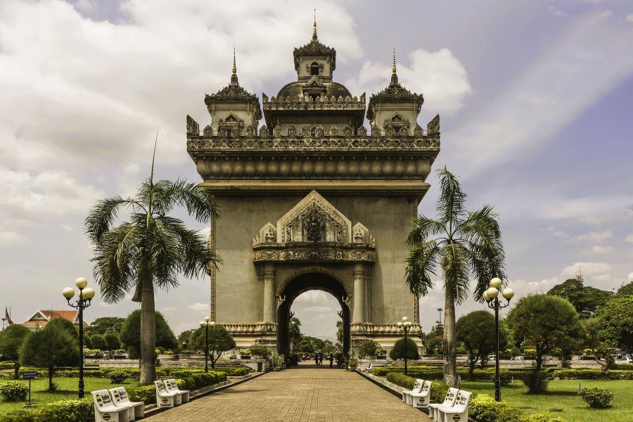
Patuxai in Vientiane (Source: @DerFussi via Wikimedia Commons)
Champasak is the hottest place of the three. April is the hottest month here, having an average low of 26.1°C and a high of 35°C. On the other hand, the coolest month is December with an average low of 20°C and a high of 30.5°C. These temperatures signify the tropical monsoon climate, pretty much the same at Hue and Da Nang in the North Central Coast of Vietnam.
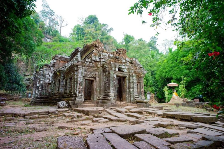
Wat Phou (Source: Ko Hon Chiu Vincent via UNESCO World Heritage Centre)
Champasak has a rainfall and humidity pattern rather similar to Luang Prabang but with greater amounts. The most rain of 226,06 millimeters happens here in September, while the rainy season lasts from March to January.
On the humidity side, the more humid season of the year lasts for almost 10 months, again with July as the most oppressive.
If you are planning a trip to Champasak, the best time for it would be late November to early February. There’s another option of early November to early March for people who enjoy the heat too.

Tad Fane Waterfall (Source: World Travel Guide via Facebook)
Despite being completely surrounded by neighboring countries, Laos still has diverse landscapes of mountainous, plateau, and plain regions, highlighted by the great Mekong River. These landscapes hence create different climate and weather patterns in this country as well, making your experience here more interesting.
We hope this blog article has provided you with the most common knowledge about the weather in Laos, and furthermore, helped you better arrange your trip(s) to this pretty much unknown country of Southeast Asia.